Blizzard Of '78: Barry Burbank's Memories Of The Historic Storm
BOSTON (CBS) - It's the 40th anniversary of the infamous Blizzard Of '78.
Most folks that experienced this paralyzing mega-storm of epic proportions can recall many vivid details of how it affected them. At that time, I was the chief and only meteorologist at WCSH-TV NewsCenter6 in Portland, Maine and three weeks away from beginning my career here at WBZ-TV! I was hired in January and was set to begin forecasting in Boston on March 1, 1978.
The Blizzard Of '78 started in Boston around 7:30 a.m. on Monday, February 6. I was living in Maine and from home that morning, I listened to my mentor, meteorologist Don Kent, on WBZ Radio.
I later heard meteorologist Bruce Schwoegler update the forecast at midday and listened to his updates early that afternoon as I drove to work in Portland. Bruce was really wound up and was pulling out all the stops for a blockbuster blitz.
It was great catching up with Bruce and reminiscing about the Blizzard Of '78.

It sure was a long haul for him here that week of the blizzard!
BLIZZARD MEMORIES
Back in those days, there was, of course, no internet and no way to access any type of meteorological information at home.
On top of that, the television station only had an Associated Press machine that spit out national, state and some local news stories along with temperatures and the official forecasts from the National Weather Service. Consequently, I spent most of my time every day at the National Weather Service Forecast Office at the Federal Building in Portland, Maine. I had done this from the beginning when I landed my first forecasting job up there in early January 1976. Fortunately, the NWS was about 4 blocks from the TV station but it was all uphill running back to the station with my clipboard of notes that I would use on the studio weather maps. It kept me in great shape!
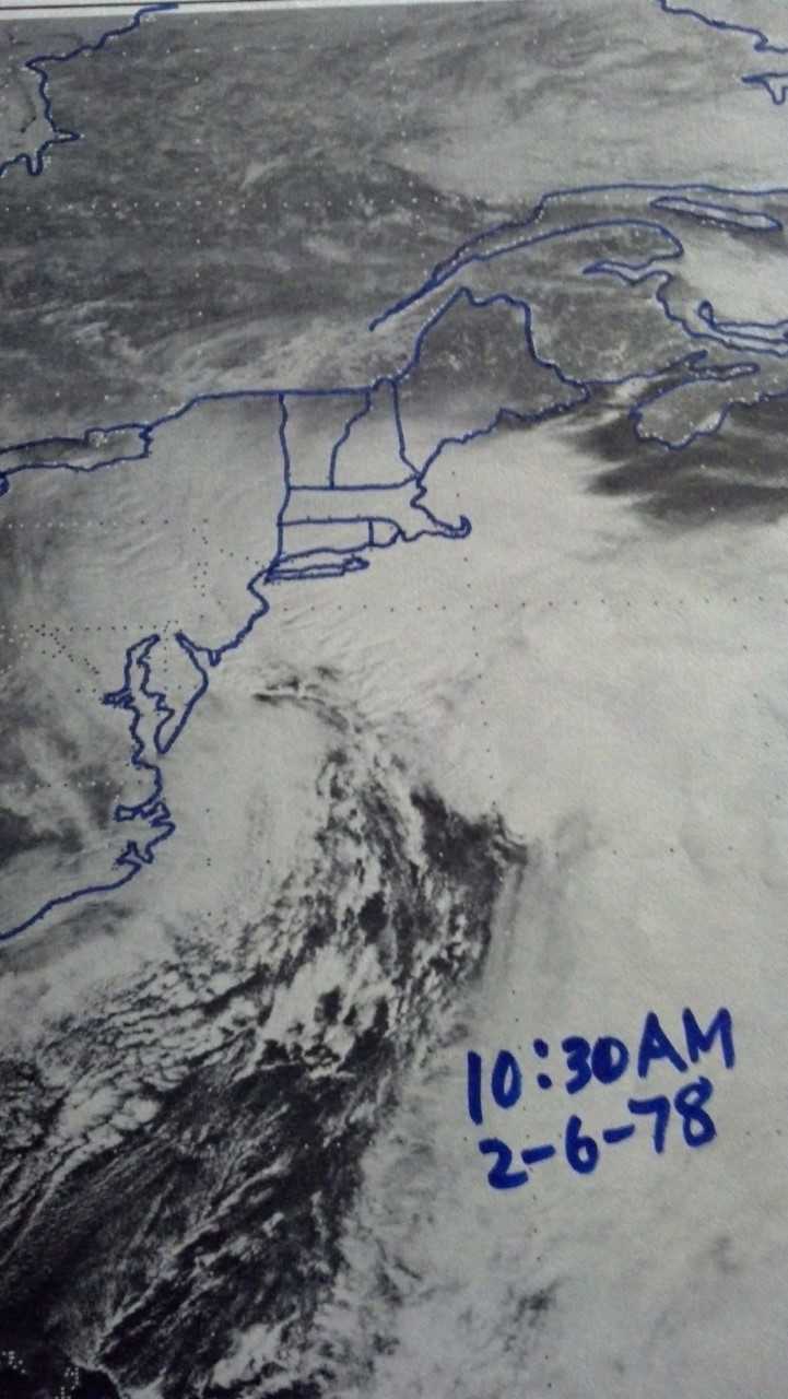
On that February 6, 1978, it started snowing just after noon in Portland. As I started studying the data and the weather maps at the NWS early that afternoon, my head started spinning because the impending setup seemed unimaginable. I was wondering if such a beast of a storm was possible. Keep in mind that there was limited guidance for formulating forecasts unlike the myriad of mathematical/meteorological models that are at our fingertips today. With that said, the main model of the day known as the LFM2, limited area fine mesh model, was amazingly accurate days in advance. As I digested some of this model's earlier runs going back to February 4-5, its solutions were consistent and that gave me some confidence. Satellite pictures, weather observations and reports were beginning to reveal that an explosive development was in the works.
A parcel of intensifying atmospheric energy was going to shift, dig and rotate from the Great Lakes and Ohio Valley to the Mid-Atlantic States and feed on some tropical moisture just off the South Carolina coast associated with a weak extratropical disturbance. The approaching energy would certainly trigger deepening of the coastal system. Furthermore, the huge difference in air pressure from the center of the ocean storm ranging back to the strong high pressure ridging across Quebec, Ontario into the Midwest meant that wild gales would be generated.
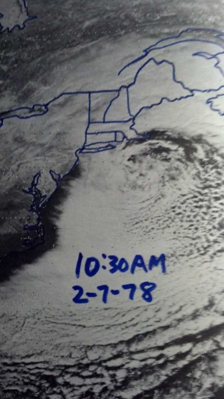
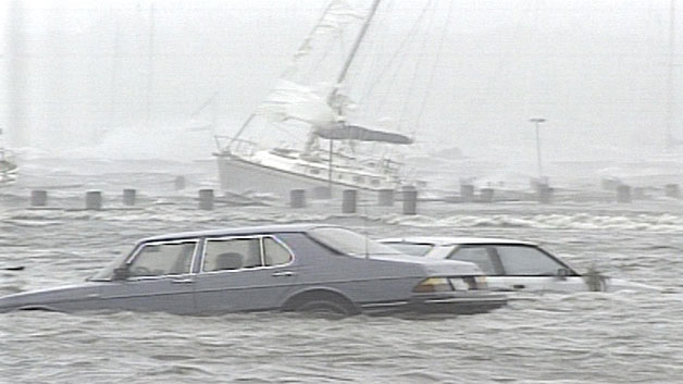
The more I studied, the more concerned I became for the southern sections of my forecast region of ME and NH. I was worried more about southern New England because it appeared the maximum impact was going to occur there. Upon realization that the developing storm could be trapped underneath its upper level system, inevitable blocking meant that this beast wasn't going to exit fast. A long spell of strong winds with a very large fetch blowing across the Gulf of ME onto our coastline meant a potential disaster. The onshore component of wind would exacerbate the storm surge for 3-4 consecutive tide cycles. Due to astronomical conditions of the new moon making a close approach to Earth, tides were abnormally high to begin with. The record-breaking tides were highest late morning on February 7. The devastation from the southern ME coast and all along the NH coast to the entire coast of MA was unbelievable. It really was a cataclysmic event along the New England coastline.
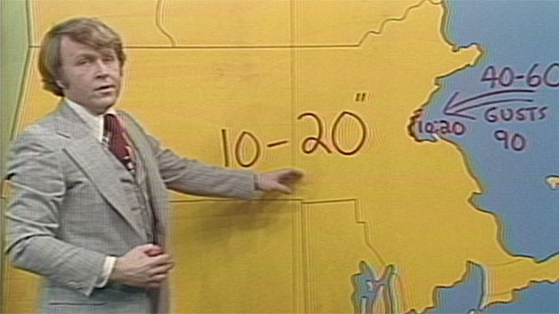
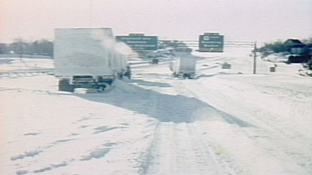
In my forecast area of Maine and New Hampshire, the snowfall was actually somewhat less than I had predicted. Only 10-15" accumulated there as this area was positioned in a dry slot from time to time. The main banding of snow crushed eastern MA (excluding Cape Cod) in the Rt. 128/I-95 corridor from Cape Ann through Boston to Providence where 25-45" mounted up and drifted severely by the fierce wind which gusted to 79 mph at Boston and 93 mph at Chatham.
For many many years, WBZ Radio was branded as "The Spirit Of New England." A genuine spirit of New England emerged as the Blizzard Of '78 unfolded. It brought out the best in us - neighbors helping neighbors, store owners giving away items and stranded travelers welcomed in the homes of caring strangers. Many friendships were made through the hardship of enduring the worst storm in a century!
Back then, storm coverage on television was minimal compared to today. As the Blizzard of '78 became a monster, the intervals of coverage increased in length and frequency but it never really became continuous through the day or night. For years after the blizzard, coverage was comprised of periodic cut-ins on the hour or half hour. Continuous coverage during the more impactful storms has been much more prevalent in the past 10-15 years.
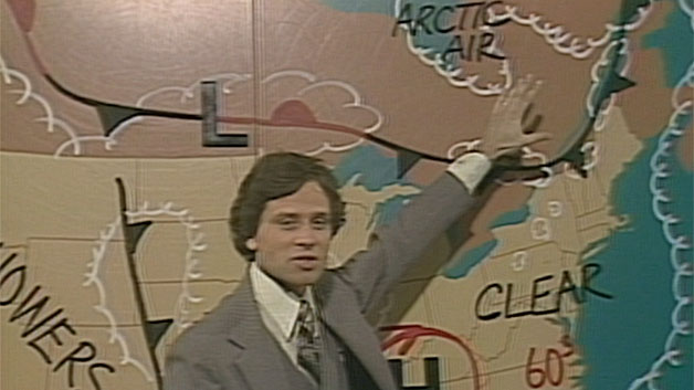
Through 1981, we only had a real New England temperature map and a national map in the studio depicting the high and low pressure systems. we would use tempra markers on these maps and we had to wash them off after each broadcast. Computer graphics and the green screen were introduced in the early 80s and nowadays, we have awesome computer graphics to display an array of colorful maps revealing all types of parameters from snowfall bands to precipitation types to windchills to dewpoints, etc.

OTHER MEMORABLE STORMS
There are numerous other storms that come to mind that I was forecasting and I will mention a few that are foremost in my mind.
April 6-7, 1982
Bruce Schwoegler was on vacation in Florida so I was subbing on the evening shows for several days leading to and through a major late season snowfall. The prediction was accurate well in advance of the storm strike. The storm produced 10-20" of powder snow in the region with Boston receiving 13". There was considerable blowing and drifting and record low temperatures in the teens!
April 1987
Lots of rain early to mid month generated major flooding in parts of Maine, southeastern New Hampshire and northeastern Mass.
April 28-29, 1987
One of my greatest forecast triumphs ever!
After forecasting on the night of April 26th that "the potential exists for the biggest snowstorm you have ever seen so late in the season" for April 28th into early on the 29th, the snowfall ranged from a coating to slight amounts on parts of the South Shore to 4"+ in Boston up to 6-10" in the nearby suburbs to 15-22" in much of Worcester County! It was a pasty, wet snow that caused much tree damage and power outages.
Hurricane Bob in August 1991 and the "Perfect Storm" in October 1991
Bob was the last real big hit New England has received from a hurricane. Cape Cod was impacted the most with wind gusts of 100-120 mph.
The Perfect Storm was a strong nor'easter that absorbed Hurricane Grace way out in the Atlantic and ultimately evolved into another small unnamed hurricane late in its life cycle!
The Superstorm Of March 1993
A massive storm that affected 26 states from the Gulf of Mexico to New England. Four states (GA, NC, TN & MD) set all-time statewide records for deepest snow. Blizzard conditions from Birmingham (17") to Boston (13"). Up to 6" fell in spots on the FL Panhandle ranging up to 60" in the smoky Mts. Of TN! Widespread damage from the 11 tornadoes & 100 mph wind gusts in thunderstorms crossing FL, a hurricane-like storm surge on Florida's Gulf Coast, damaging wind gusts from Cuba (100 mph) to Boston (81 mph). A wall of snow surged through the Boston area releasing a foot in a short period of time.
The Snow Blitz Of Late 1995 Into 1996
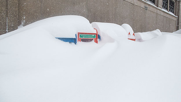
A parade of storms started in December of 1995 and lingered into January 1996. This is on my memory list because I had severely sprained my ankle in a snow-tubing accident a few days before the New Year. Consequently, I was on crutches for about 5 weeks while these big snow storms were happening. A couple of nights I couldn't get out in the snow to go home so I slept a few hours on the small couch in the News Director's office! The WBZ weather office was far way from the studio so I was exhausted from the traveling back and forth dealing with all the weathercasts. Snow fell into April of that year yielding Boston's snowfall record of 107.66" that was broken in the snow blitz of 2015!
The April Fool's Blizzard Of 1997
Another great forecast triumph.
After a beautiful Easter Sunday at 65 degrees on March 30, I delivered my 6 p.m. weathercast stating that "one of the biggest snowstorms that you have ever seen is quite likely tomorrow night (March 31) into Tuesday (April 1)". many people thought it was an April Fool's joke but I was not fooling!
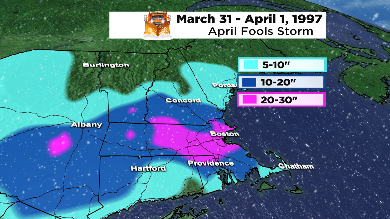
Rain started on Monday morning March 31 then transitioned to snow later in the afternoon then turned into a raging blizzard featuring frequent lightning & thunder and gusts past 50 mph during the night. Boston ended up with its 4th biggest storm on record with 25.4" in much less than 24 hours! Due to the waterlogged nature of the snow, widespread tree damage and power outages occurred.
December 23, 1997
My worst forecast ever and I am sure the worst for all the other meteorologists on duty that morning!
It was Tuesday morning 12/23... I was working the morning shift and predicted for that day 1-3" of snow in the Boston area and up to 3-5" across northern MA into southern NH... The snow hadn't begun before 7am and it was the last day of school before the holiday break. No schools were cancelled at that point. The snow started after 7am and quickly became very heavy with visibility down to almost zero at times. There was NO wind, the snow was coming straight down and accumulated quickly. School superintendents were calling me for updates. Many schools dismiised early in the middle of the storm! Snowfall amounts ranged from 6-12" along the MA Pike up to 16-24" over much of northern MA into southern NH. To this day, it is a spooky situation with no adequate explanation what happened. There was only a very weak wave of low pressure along a frontal boundary- really no defined storm. Case studies have revealed no answers to this puzzling scenario!
Presidents' Day Storm Of February 17-18, 2003
This holds the record (27.6") for the biggest snowstorm ever in Boston exceeding the Blizzard of '78 (27.1"). Controversy remains over this record.
December 9, 2005 "Wintercane"
Rapidly developing storm near Cape Cod created havoc as winds gusted into the hurricane-force range across the region. Some gusts exceeded 100 mph on Cape Cod. Much wind damage occurred and the ferocity of the storm for 1-3 hours was insane. Temperatures rose rapidly then tanked over southeastern MA as rain switched to thundersnow. Whiteouts resulted in horrible traveling conditions with snowfall rates of 3 to 9" per hour. A very reliable report of almost 9" of snow fell in Andover in about 55 minutes! The storm rapidly exited.
Historic Floods In October 2005 & Mother's Day 2006
8-12" of rain over northeastern MA into southeastern NH & parts of ME on Mother's Day weekend.
February 8-9, 2013
A late starting winter and the biggest storm of that winter at 24.9" It is Boston's 5th biggest snowstorm on record.
January 24-February 22, 2015: Record-Breaking Snow and Cold
Boston's new 30-day snowfall record of 94.4" smashes the previous record of 58.8" for the 30-day period ending on February 7, 1978!
There were 4 major snowstorms in that time frame and 2 of them are in the city's top ten storms at number 6 and number 7! Many people have said to me that it must have been a very tough period to forecast.
I tell them that it was a relatively easy forecasting stretch because every one of the storms produced powder snow everywhere even on Cape Cod, there were no rain/snow/sleet/freezing rain lines.
It has to be a once in a couple centuries storm!!!! The seasonal snowfall of 110.6" eclipsed the 107.6" set in 1995-96!