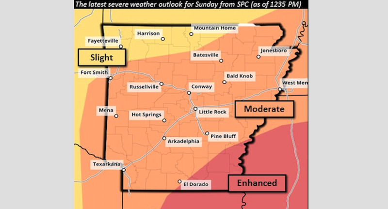
Nearly all of Arkansas is at an enhanced risk of severe weather on Easter Sunday, with the greatest risk covering the southeast corner of the state, forecasters said.
“All modes of severe weather are possible, including large hail, damaging winds and tornadoes,” according to a statement released by the National Weather Service.
Forecasters predicted Arkansans will first get a round of storms tonight, with hail being the primary threat. A second round of storms is expected to begin Sunday morning, bringing a chance for wind, hail and tornadoes.
A third round of storms is possible Sunday afternoon and evening in Northwest Arkansas, the weather service said.
The National Storm Prediction Center in Oklahoma City already has issued a forecast that includes the state's southeastern quadrant as part of a large swath of the South under a moderate risk for severe weather Sunday.

Dylan Cooper, a meteorologist with the service's office in North Little Rock, said identifying a "moderate risk" of severe weather is rare to issue in a forecast two days out.
The last time similar guidance was issued was April 25, 2014, two days before the April 27 Vilonia/Mayflower tornadoes that claimed 13 lives, he said.
Throughout Saturday night and Sunday’s storms, forecasters expect heavy to excessive rain to fall across the southern half of Arkansas, with over to three inches predicted through early Monday in some areas. Flash flooding is possible, according to the weather service.
The storms are predicted to be at their worst Sunday afternoon stretching into early evening, though forecasters said they might continue into the night.
Forecasters encouraged residents to prepare for the possible storms and to make sure they have multiple means to receive weather warnings.
Information for this article was contributed by Noel Oman of the Arkansas Democrat-Gazette.